The Transport for NSW trip planner has been going through some great changes as we continue to embrace the Mobility-as-a-Service (MaaS) philosophy. The recent updates include additional travel options as well as more seamless multi-modal trip plans to help enable the MaaS ecosystem in NSW.
In what is phase 1 of the project, the TfNSW Trip Planner has been updated to include additional travel options along with desired travel times. These changes will allow customers to make more informed choices when planning their trip. The key changes include:
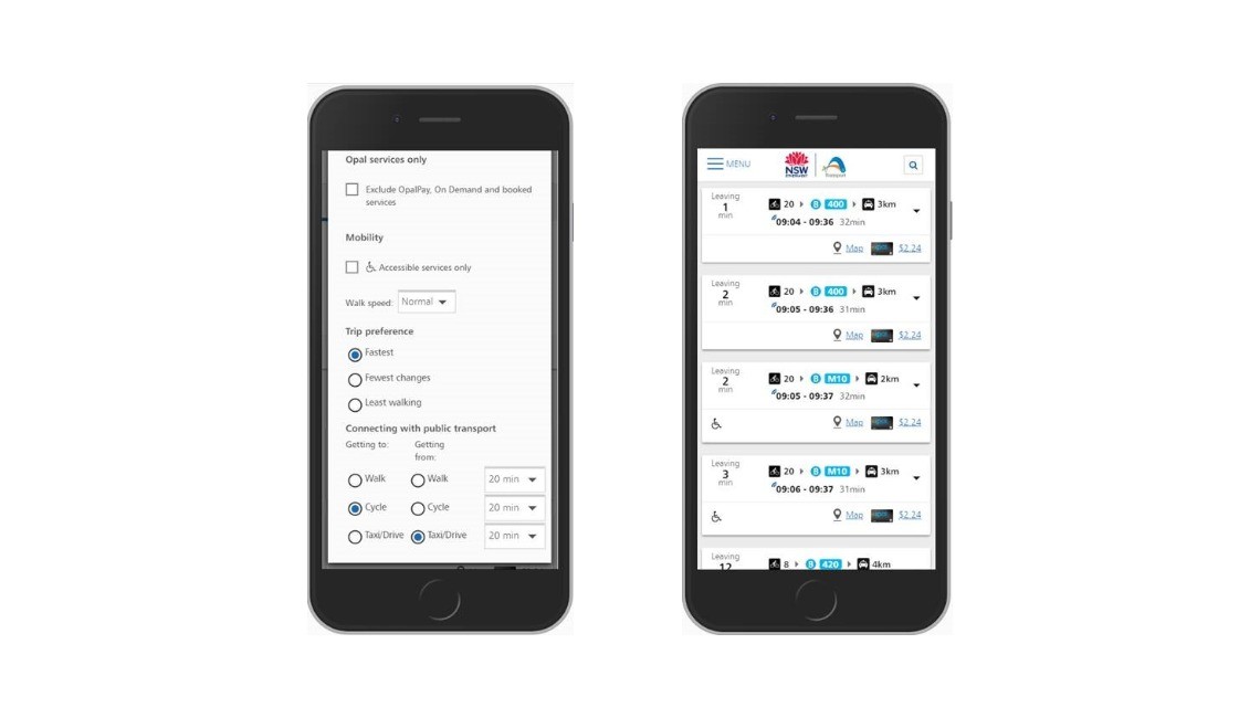
- Cycling has been added as a mode, while the existing options of Walking and Driving have been updated.
- Customers can select from Walk, Cycle or Drive to get to and/or from their public transport stops and set how long they’re happy to walk, cycle or drive for.
- Where the desired travel time is long enough, customers will receive the option to walk or cycle the entire way - this shows at the bottom of all trip options.
The biggest advantage is that it allows customers to mix modes and tailor the results to their needs, mixing public transport with private options to connect the first and last mile of the journey. For example, a customer can choose to cycle to the train station and drive at the other end, something that is unique in the TfNSW Trip Planner compared to other apps and products.
The data is available through our Trip Planner API and is open for any third-party developer to use in their apps. The Trip Planner API offers five different endpoints that provide different functions for all your trip planning needs. The five endpoints are:
- Stop Finder API: Provides capability to return all NSW public transport stop, station, wharf, points of interest and known addresses to be used for auto-suggest/autocomplete (to be used with the Trip planner and Departure board APIs).
- Trip Planner API: Provides capability to provide NSW public transport trip plan options, including walking and driving legs, real-time and Opal fare information.
- Departure API: Provides capability to provide NSW public transport departure information from a stop, station or wharf including real-time.
- Service Alert API: Provides the capability to display all public transport service status and incident information (as published from the Incident Capture System).
- Coordinate Request API: When given a specific geographical location, this API finds public transport stops, stations, wharfs and points of interest around that location.
To have a look at the Trip Planner API go to https://opendata.transport.nsw.gov.au/dataset/trip-planner-apis. Make sure to read the documentation available before using the API.
There are also some exciting changes coming soon to the Trip Planner following our MaaS Trip Planner Trial innovation challenge, phase 2 of the project. The innovation challenge encouraged small and large transport service providers to apply to join a trial that would include their services in the TfNSW Trip Planner. The main selection criteria for the challenge was for the service provider to have an API so that they could easily be integrated with the trip planner.
Applications closed on July 10 and we are now in the process of working with the selected finalists to get their final offering into the trip planner. This is a very thorough process since the criteria and requirements are very strict to ensure we provide the best services and experience to our customers. We hope to have some of these services integrated with the trip planner by the end of the year. To read more about the MaaS Trip Planner trial visit our innovation invitation page.
Exciting times ahead for the TfNSW Trip Planner and travel options for customers. Keep up to date with everything that is going on here on our website, the Open Data Forum and our Twitter @DataTfNSW.