
For the last blog post in our 3-part series on OpenStreetMap (OSM), we would like to focus on what the future of TfNSW’s Trip Planner might be if we harnessed the power of OSM. Trip Planner has already embraced several recent changes (see post Changes and New Features in the TfNSW Trip Planner, such as offering mix modes of transportation to allow more tailored results. The envelope could be pushed further, however, with two improvements that can be done in the near future: indoor mapping and offering personalised cycle pathway routes.
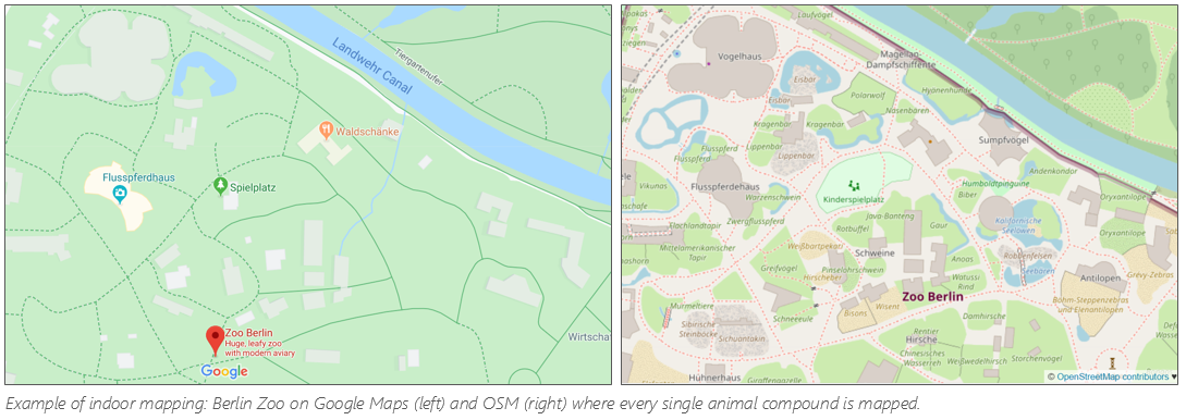
We have, for the most part, a frictionless experience when it comes to outdoor navigation. We have crowd-sourced and intelligent navigation to guide us to our destination with the least amount of traffic, view how far away our bus is with real-time apps and tracking of our food orders to our front doors. But what about navigating the insides of complex buildings and infrastructure such as our transport network? Imagine being a first time international visitor to Sydney, fresh off Central Station platform 21, needing to catch the Light Rail to Dulwich Hill - but first you want to grab a coffee and pick up some brochures from a tourist office. Normally, you would have to figure this out for yourself and connect the dots. However with indoor mapping, this could be solved, as you can receive proper guided instructions through the station and where to go for each item. This would be especially beneficial to TfNSW’s customers who require assistance, as it would provide crucial information for them to navigate confidently and independently through the transport network.
The application of indoor mapping also extends to other domains outside of public transport. Have you ever looked at a shopping centre map with a “You are here” indicator and still been confused as to where you actually are, and about which direction you need to head to find that shoe shop? What about navigating to your check-in counter at the airport, finding your lecture room at your university campus, or finding your way to your relative’s hospital bed? The list goes on. You’ve found your way to the building, but finding your way around inside to the correct floor or area can be frustrating and time consuming. OSM has been tackling this challenge, and TfNSW can use this data to bring a complete and precise end to end experience for their customers.
Cycle routes based on a customer’s preferences is another enhancement that can be made to TfNSW’s Trip Planner using OSM. It’s possible to provide customers with detailed route information based on their preferences, such as wanting the shortest route to their destination, avoiding major roads, desiring challenging uphill routes or beginner flat pathways. All this information is being captured by platforms like OSM as countless of contributors add details like incline information on roads, and even their own personal routes they have found are a “good route to cycle”. Needless to say, getting more people to cycle would not only reduce congestion on roads and overcrowding on public transport, but also contribute to environmental and individual health.
TfNSW is taking steps to providing better trip planning information to customers. Harnessing the data available on OSM would be a great first step to offer customers a tailored journey and a truly seamless experience.